Ramanathapuram district
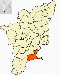
 Ramanathapuram District is an administrative district of Tamil Nadu state in southern India. The city of Ramanathapuram is the district headquarters. Ramanthapuram District has an area of 4123 km². It is bounded on the north by Sivaganga District, on the northeast by Pudukkottai District, on the east by the Palk Strait, on the south by the Gulf of Mannar, on the west by Thoothukudi District, and on the northwest by Virudhunagar District. The district contains the Pamban Bridge, an east-west chain of low islands and shallow reefs that extend between India and the island nation of Sri Lanka, and separate the Palk Strait from the Gulf of Mannar. The Palk Strait is presently navigable only by shallow-draft vessels.
 In the early 12th century, Syed Ibrahim Shaheed of Medinah defeated the then ruler Vikrama Pandiyan and captured the Bouthiramanikkapattinam province (Today's Ervadi and surrounding places), but 12 years later Jamara Kolagala Pandiyan, son of Thiruppandiyan, re-captured the Ramanathapuram throne through a treaty with Syed Ishaq (son of Syed Ismail the brother of Badusha Sulthan Syed Ibrahim Shaheed), who got Bouthiramanikkapattinam province. Both their heirs ruled their provinces until the late 16th century.
In the early 15th century, the present territories of Ramanathapuram district, comprising taluks Tiruvadanai, Paramakudi, Kamuthi, Mudukulathur, Ramanathapuram and Rameswaram, were included in the Pandyan Empire. For a short period, this area was under the Chola Kings when Rajendra Chola brought it under his territory in 1063 AD. In 1520 AD, the Nayaks of Vijayangar took over this area under their control from the Pandyan dynasty for about two centuries, Marava chieftains-Sethupathis who were Lords under Pandiyan Kings and reigned over this part (17th century). At the beginning of the 18th century, family disputes over succession resulted in the division of Ramanathapuram.
In the early 12th century, Syed Ibrahim Shaheed of Medinah defeated the then ruler Vikrama Pandiyan and captured the Bouthiramanikkapattinam province (Today's Ervadi and surrounding places), but 12 years later Jamara Kolagala Pandiyan, son of Thiruppandiyan, re-captured the Ramanathapuram throne through a treaty with Syed Ishaq (son of Syed Ismail the brother of Badusha Sulthan Syed Ibrahim Shaheed), who got Bouthiramanikkapattinam province. Both their heirs ruled their provinces until the late 16th century.
In the early 15th century, the present territories of Ramanathapuram district, comprising taluks Tiruvadanai, Paramakudi, Kamuthi, Mudukulathur, Ramanathapuram and Rameswaram, were included in the Pandyan Empire. For a short period, this area was under the Chola Kings when Rajendra Chola brought it under his territory in 1063 AD. In 1520 AD, the Nayaks of Vijayangar took over this area under their control from the Pandyan dynasty for about two centuries, Marava chieftains-Sethupathis who were Lords under Pandiyan Kings and reigned over this part (17th century). At the beginning of the 18th century, family disputes over succession resulted in the division of Ramanathapuram.
In 1795, the British deposed Muthuramalinga Sethupathy and took control of the administration of Ramanathapuram. In 1803 Mangaleswari Nachiyar was made the Zamindar of Sivagangai. After passing of Queen, the Marudhu Brothers took the charge by paying regular revenue to the East India company. In 1801 the Marudhu Brothers of Sivaganga revolted against the British in collaboration with Kattabomman of Panchalamkurichi. Colonel Agnew captured Marudhu Brothers and hanged them and made Gowri Vallbah Periya Udaya Thevar as Zamindar of Sivaganga. After the fall of Tipu Sultan, British took the control and imprisoned the Nawab. In 1792 the Zamindari system was abolished and a British Collector was appointed for administration.
After the period of Sethupathis, in 1910, Ramanathapuram was formed by clubbing portions from Madurai and Tirunelveli district. This district was named Ramanathapuram. During the British period this district was called "Ramnad". The name remained after independence. Later the district was renamed to Ramanathapuram to be in conformity with the Tamil name for the region. Couple of years back Indian Archaeological Department found some ancient pottery in Theriruveli, 32 km away from Ramanathapuram.
)
Ramanathapuram district in Tamil Nadu, India
Demographics
It has a population of 11,87,604 (as of 2001). It is 25.46% urbanised.[1] The district has a literacy of 73.05%, slightly below the average for the state. 78.15 % of the population are Hindus, 14.7% are Muslims and Christians constitute 7.08% of the district population. This district has the highest number of Muslims (as a percentage of total population) in the state followed by Vellore District.[2] The religious composition of the district is 72.41% Hindus, 22.4% Muslims, Christians 5.08% and others 0.11%.History
)
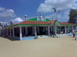
Erwadi durgah in Ramanathapuram District
)
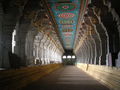
Corridors of the Rameshwaram temple
In the early 12th century, Syed Ibrahim Shaheed of Medinah defeated the then ruler Vikrama Pandiyan and captured the Bouthiramanikkapattinam province (Today's Ervadi and surrounding places), but 12 years later Jamara Kolagala Pandiyan, son of Thiruppandiyan, re-captured the Ramanathapuram throne through a treaty with Syed Ishaq (son of Syed Ismail the brother of Badusha Sulthan Syed Ibrahim Shaheed), who got Bouthiramanikkapattinam province. Both their heirs ruled their provinces until the late 16th century.In 1795, the British deposed Muthuramalinga Sethupathy and took control of the administration of Ramanathapuram. In 1803 Mangaleswari Nachiyar was made the Zamindar of Sivagangai. After passing of Queen, the Marudhu Brothers took the charge by paying regular revenue to the East India company. In 1801 the Marudhu Brothers of Sivaganga revolted against the British in collaboration with Kattabomman of Panchalamkurichi. Colonel Agnew captured Marudhu Brothers and hanged them and made Gowri Vallbah Periya Udaya Thevar as Zamindar of Sivaganga. After the fall of Tipu Sultan, British took the control and imprisoned the Nawab. In 1792 the Zamindari system was abolished and a British Collector was appointed for administration.
After the period of Sethupathis, in 1910, Ramanathapuram was formed by clubbing portions from Madurai and Tirunelveli district. This district was named Ramanathapuram. During the British period this district was called "Ramnad". The name remained after independence. Later the district was renamed to Ramanathapuram to be in conformity with the Tamil name for the region. Couple of years back Indian Archaeological Department found some ancient pottery in Theriruveli, 32 km away from Ramanathapuram.
Tourism
)
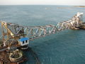
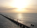
Pamban rail bridge connecting Pamban island with the Indian mainland
)
Palk strait between Pamban island and Indian mainland
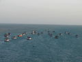
)
Fishing boats on Palk Strait
- Erwadi
- Sayalgudi
- Paramakudi
- Kamudakudi
- Parthibanur Dam
- Kadaladimaradai
- Thiruvetriyur (Patham Priya Koil)
- Ervadi Durgah
- Kattupalli
- Valinokkam (Ummayyah Al Badawiyyah Imran Shahid Durgah & Salt Corporation)
- Sundaramudayan (ILme Yaseen @ Seeniappa Shahid Durgah)
- Meesal Kilavanery (Umar Qattab Shahid Mosque)
- Thachu oorani (Mursal Ibrahim shaheedh Mosque)
- Mandapam coast guard
- Maraikkayar pattinam (Fisheries aquarium)
- Kuruvadi
- Uchippuli beach
- Sikkal
- Kilakarai
- Mudukulathur - Chinthirankudi, Kanchirankulam (bird sanctuary)
- Orivayal (Birds on Dams)
- Mariyur (Nalla Thanni Theevu) (Water-purifying plant)
- Sethupathy palace
- Pudhunagaram (uchippuli) (Nagore andavar dargah)
- Ariyaman beach
- Rameswaram
- Danushkodi
- Pamban bridge
- Devipattinam (Navapasanam)
- Rajasingamangalam (2nd Biggest Canal in Tamil Nadu)
- Perungulam (Saragappa dharga)
- Panaikulam (Baba-Syed Muhammed Mosque)
- Sethukkarai
- Central Marine Fisheries Research Institute
- Seranthai water Purifying plant (salt water has been changing into drinking water)
- Bogalur mosque
- Therkutharavai (A beautiful village close to the district of Ramanathapuram)
- Abiramam (Big Mosque)
- Therkkuvaniveethi
- Theriruveli Rawther Shahib
Notable people
- A. P. J. Abdul Kalam, India's 11th President[citation needed]
- A. Anwar Rhazza, Ex-Minister for Labour, Tamil Nadu Government[3]
- Kamal Haasan, Tamil cinema actor[citation needed]
- Vikram Kennedy, Tamil cinema actor[citation needed]
- Senthil, Tamil cinema comedy actor[citation needed]
கருத்துகள் இல்லை:
கருத்துரையிடுக